Thermal Drone Search for Missing Pets: How It Works

When a dog or cat goes missing, owners often wonder whether a drone can search areas that are difficult to cover safely or efficiently from the ground. A thermal drone search for missing pets uses an infrared camera to detect temperature differences, helping the operator identify possible animal heat signatures in fields, wooded areas, drainage corridors, parks, neighborhoods, and other accessible search areas.
Thermal imaging does not automatically identify a missing pet, track an animal through its microchip, or see through solid objects. Each possible heat signature must be evaluated using both thermal and visual cameras, along with the animal’s size and behavior, the surrounding terrain, reported sightings, and its last-known location.
This guide explains how Sight Hawk Drone plans and conducts a professional thermal drone search, when thermal imaging is most effective, what the camera can and cannot detect, what clients can expect during the search, and why locating a pet is only one part of the recovery process.

How a Thermal Drone Search for Missing Pets Works
A professional thermal drone search is not simply a matter of launching the aircraft and flying at random. The search begins with gathering information, evaluating the location, and developing a plan based on where the pet was last reliably seen and how the animal is likely to behave.
Pre-Search Consultation and Planning
Before launching the drone, Sight Hawk Drone speaks with the owner to gather the pet’s description, last-known location, time missing, temperament, direction of travel, and any reported sightings. Recent sightings are evaluated carefully because an incorrect or mistaken report can redirect the search away from the area where the pet is most likely to be.
The surrounding terrain, nearby roads, wooded areas, drainage corridors, water sources, fields, neighborhoods, and other possible travel or hiding areas are also considered. Before determining where the drone can operate safely and legally, review airspace, weather, visibility, property access, and potential flight hazards.
Not every missing-pet case is immediately suited for a drone search. In some situations, the most helpful first step may be establishing a scent station, distributing flyers, reviewing security-camera footage, checking nearby shelters, or waiting for a reliable sighting that provides a more focused search area.
Establishing the Search Area and Launch Location
The search is generally centered on the pet’s last confirmed location or the most reliable recent sighting. Sight Hawk Drone establishes a safe and legal launch location that provides practical access to the areas the pet may have entered. The drone does not always launch from the exact point where the animal disappeared because trees, power lines, buildings, airspace restrictions, property access, or other hazards may require a nearby location.
The initial search area is prioritized using the pet’s direction of travel, elapsed time, temperament, terrain, nearby resources, and possible barriers. Areas that may provide food, water, shelter, or quiet hiding places are given particular attention. The plan may be adjusted during the flight if new information or a possible heat signature identifies another area requiring closer examination.
Searching With Thermal and Visual Cameras
Sight Hawk Drone uses a DJI Matrice 30T equipped with thermal and visual cameras. The drone is typically flown about 150 to 200 feet above the search area, depending on terrain, obstacles, airspace, weather, and the level of detail needed.
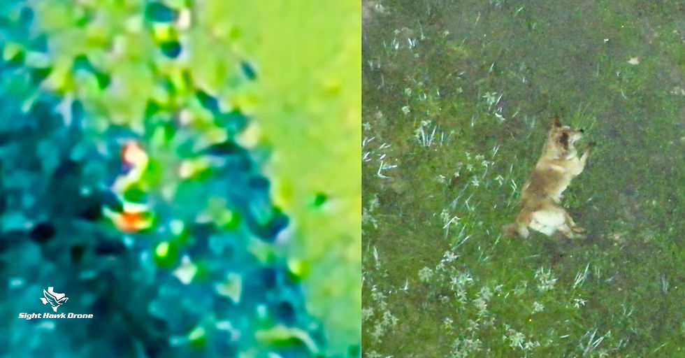
The operator methodically scans the search area in organized flight paths while watching for heat signatures that could match the size, shape, movement, and behavior of the missing pet. The thermal camera helps reveal temperature contrast, while the visual camera is used to examine the same location and gather additional identifying details.
Thermal detection is not automated confirmation. A warm object may be a dog or cat, but it could also be wildlife, livestock, a person, machinery, pavement, roofing material, or another heat-retaining surface. Carefully evaluate each possible target before treating it as a credible sighting.
When Thermal Imaging Works Best
The effectiveness of thermal imaging depends on temperature contrast, terrain, vegetation, weather, and the pet’s behavior. Although thermal cameras can operate during daylight, nighttime searches are generally more effective because the ground and surrounding objects have had time to cool.
Cooler Conditions Create Better Temperature Contrast
Dogs, cats, people, and other animals naturally produce body heat. When the surrounding ground, vegetation, buildings, and other surfaces are cooler, an animal’s heat signature is more likely to stand out on the thermal display.
After a hot or sunny day, pavement, roofs, vehicles, rocks, fences, and other surfaces may continue releasing stored heat. These warm objects can reduce contrast or create shapes that initially resemble animals. Allowing the environment additional time to cool can improve the operator’s ability to separate a possible animal from the background.
Search Timing for Missing Dogs and Cats
A thermal drone search normally begins about one hour after sunset. This allows sunlight-warmed surfaces time to begin cooling and improves the temperature contrast between an animal and its surroundings. Because sunset times change throughout the year and with daylight saving time, searches are scheduled based on local conditions rather than a fixed start time.
Searches can continue throughout the night and up to approximately one hour after sunrise. As the sun rises and begins warming the ground, roofs, pavement, fences, vehicles, and vegetation, thermal contrast may decrease, and false heat signatures may become more common.
Missing dogs may travel through neighborhoods, wooded corridors, fields, drainage areas, or other connected routes, making recent and reliable sightings especially valuable when establishing the search area. Cats often remain hidden closer to where they escaped and may become more active after the surrounding neighborhood grows quiet, so cat searches are frequently scheduled later at night.
These timeframes are guidelines, not guarantees. Weather, seasonal temperatures, terrain, airspace, the pet’s behavior, and the timing of recent sightings all help determine the most useful search window.
Daytime Visual Monitoring and Recovery Support
Daytime drone use is generally limited to situations in which rescuers or owners are actively following a known animal and need help maintaining visual contact. This is different from conducting a broad thermal search. During daylight, the drone’s visual and zoom cameras can observe the animal from a distance while reducing the need for people to remain in constant ground pursuit.
Continuous chasing can increase an animal’s fear and cause it to travel farther, enter traffic, or hide in a more difficult location. Once the drone has the animal in view, rescuers can back away and give it an opportunity to settle while the operator continues monitoring its location and movement from the air.
Professional darting teams generally need someone to have eyes on the animal before they will respond to the location. If the animal is safely tranquilized, continued aerial observation may also help maintain visual contact while the medication takes effect, reducing the risk of the animal moving into heavy vegetation or another location where it could be difficult to recover.
The drone does not perform the capture or tranquilization. Sight Hawk Drone provides aerial observation and location assistance while coordinating with the owner, ground rescuers, trappers, or qualified darting professionals responsible for the recovery.
What Thermal Cameras Can and Cannot Detect
Thermal imaging is a valuable search tool, but it is not X-ray vision, and it does not reveal everything within the search area. Understanding these limitations helps owners maintain realistic expectations and explains why a pet may remain undetected even when the drone searches nearby.
Thermal Imaging Cannot See Through Solid Objects
A thermal camera detects temperature differences on surfaces that are visible to the sensor. It cannot see through buildings, vehicles, sheds, roofs, patio covers, fences, heavy debris, or other solid objects. If a pet is underneath or inside one of these areas, its body heat may be completely blocked from the drone’s view.
Thermal imaging also cannot identify a pet by its name, microchip, or collar information. When a possible animal is detected, the visual and zoom cameras may help evaluate its size, shape, movement, and visible markings, but distance, darkness, vegetation, and the animal’s position can still limit positive identification.
Vegetation, Terrain, and Weather Affect Visibility
Open fields, short grass, clear drainage corridors, and areas with unobstructed views generally provide better thermal visibility. Dense tree canopy, thick brush, tall vegetation, deep ditches, structures, and uneven terrain can partially or completely hide an animal’s heat signature.
Rain, humidity, wind, ground temperature, and changing weather conditions can also affect image quality and animal behavior. Sight Hawk Drone can operate in many conditions, including rain and wind, but every flight must still be evaluated for safety, visibility, and whether the search is likely to provide useful information.
A Search Without a Sighting Is Still Limited Information
Not seeing the missing pet during a drone search does not prove that the animal is no longer in the area. The pet may be under solid cover, inside a structure, concealed by vegetation, outside the searched area, or inactive during the flight.
Consider a no-sighting result alongside reported sightings, security-camera footage, tracks, scent activity, shelter checks, and other search information. New credible information may justify returning to a different location or conducting another search later.
What Clients Can Expect During a Thermal Drone Search
After arriving at the search location, Sight Hawk Drone reviews the available information, establishes a safe launch area, and confirms the initial search priorities with the owner. The flight plan may change as the search progresses based on terrain, possible heat signatures, new sightings, or other information received on scene.
Live Search Viewing on a 27-Inch Monitor
Clients can watch the search in real time on a 27-inch external monitor connected to the drone controller. The display lets the owner see the same thermal and visual camera views the operator is evaluating without crowding around the controller.
The owner’s knowledge can be helpful when evaluating a possible sighting. Familiar details such as the pet’s size, body shape, gait, tail position, behavior, or reaction to certain sounds may help distinguish the missing animal from another pet or wildlife. However, live viewing does not guarantee that every heat signature can be positively identified.
Spotlight, Loudspeaker, and Location Assistance
When appropriate, the drone’s spotlight can illuminate a possible animal or recovery area for the visual camera and people on the ground. The loudspeaker can broadcast the owner’s recorded voice, a familiar command, or the sound of a squeaky toy. These tools are used carefully because a frightened animal may respond differently than it normally would at home.
If a credible sighting is made, the operator can generate a location pin that the owner opens in Google Maps by scanning a QR code from the controller. This helps guide the owner or recovery team toward the area without suggesting that the pet is wearing or being followed by a tracking device.
Battery Changes and Search Coverage
The drone must periodically return to the launch area to change the battery. Once the aircraft lands, the battery swap typically takes about 30 seconds or less, allowing the search to resume with minimal interruption.
Search duration depends on the size of the area, terrain, vegetation, obstacles, available flight paths, reported sightings, and the number of possible targets requiring closer inspection. When a pet is not located, approximately two hours is often sufficient to examine the reasonable search areas surrounding a reliable last-known location, but some cases may require more or less time.
If new credible sightings are reported later, the search may be redirected to another location. Follow-up flights are most useful when they are based on reliable information rather than repeatedly searching the same area without evidence that the pet has returned.
Locating a Missing Pet Is Not the Same as Recovering It
Finding the animal from the air is an important step, but it does not mean the pet will immediately approach the owner or allow itself to be captured. A frightened dog or cat may be in survival mode—sometimes called fear fog—and may temporarily fail to respond normally to familiar people, voices, commands, or food.
Owner-Led Recovery Comes First
When conditions are safe, the first recovery attempt generally involves positioning the owner where the pet can see or hear them without feeling pursued. The owner may be directed to sit on the ground, avoid direct movement toward the animal, speak calmly, and allow the pet time to recognize familiar sights, sounds, and scents.
If the pet moves away, the owner should not chase it. The drone can continue observing from the air while the owner remains calm and gives the animal an opportunity to settle. Recovery may require repeating this process several times and allowing the pet to decide to approach.
In some dog cases, a familiar bonded dog may be used as a “magnet dog.” Seeing and smelling a trusted companion can sometimes help a frightened dog move out of survival mode and reconnect with familiar behavior.
When a Trapper or Darter May Be Needed
Some animals cannot be safely recovered through direct owner contact. Cats frequently require a properly placed and monitored humane trap, while extremely frightened or flight-risk dogs may also need assistance from an experienced professional trapper.
If humane trapping is unsuccessful or the animal is in immediate danger, a qualified darting professional may be considered. Tranquilization requires specialized training, careful planning, and continued visual contact with the animal before and after the dart is administered.
Sight Hawk Drone is a pet-location service, not a trapping or darting company. When necessary, aerial observation can support the owner and qualified recovery professionals by helping maintain awareness of the animal’s location and movement.
Can a Thermal Drone Search Guarantee Recovery?
No drone operator or pet-recovery professional can guarantee that a missing animal will be located or safely recovered. A pet may be outside the selected search area, concealed beneath solid cover, hidden by vegetation, inside a building, or moving between locations while the search is underway.
A thermal drone improves the ability to examine large or difficult areas from the air, but it cannot track a microchip, search through satellites, or automatically distinguish the missing pet from every other animal. Treat any person or company promising a guaranteed location with caution.
The value of a professional search comes from organized aerial coverage, experienced interpretation of thermal and visual images, live observation, and information that helps the owner make better decisions about the next stage of the search.
Is a Thermal Drone Search Right for Your Missing Pet?
A thermal drone search is most useful when there is a reliable last-known location or recent credible sighting, an identifiable search area, and terrain that provides the camera with reasonable visibility. Open fields, wooded corridors, drainage areas, parks, rural property, and connected neighborhood spaces may all be appropriate depending on local conditions.
A broad drone search may be less useful when there is no reliable location information, the suspected area consists primarily of buildings and other solid cover, or the search is being redirected by an old or unconfirmed sighting. A free initial telephone consultation can help determine whether a drone search is appropriate or whether another recovery step should come first.
Sight Hawk Drone provides professional thermal drone searches and pet-recovery guidance throughout Spring, Houston, The Woodlands, Tomball, Conroe, and surrounding Greater Houston communities. No deposit or prepayment is required; clients are billed after services are rendered based on the actual search time used.
If your dog or cat is missing, contact Sight Hawk Drone to discuss the circumstances, evaluate the search area, and determine the most practical next step.
Search. Locate. Reunite.

Comments